Geographical Information System (Gis)
What Is a Geographical Information System (GIS)?
A geographical information system (GIS), also called a geographic information system, is a computer-based system for collecting, managing, analyzing, and displaying information connected to locations on Earth. In logistics and ecommerce, GIS helps organizations examine where customers, warehouses, shipments, transport routes, and delivery areas are located and how those locations relate to one another.
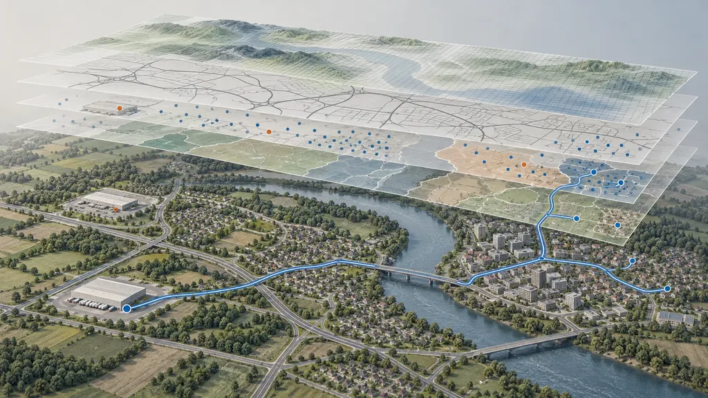
A GIS connects geographic features with descriptive information. A warehouse, for example, can be represented by a point on a map and linked to attributes such as its identifier, storage capacity, or operating hours. Roads can be represented as connected lines, while delivery territories can be represented as areas. Analyzing these features together can support decisions about facility locations, service boundaries, transport access, and distribution planning.
GIS is used in many fields beyond logistics, including environmental management, public planning, and infrastructure management. Its defining feature is spatial analysis: examining information through location, distance, direction, connectivity, and geographic relationships.
How GIS Organizes Geographic Information
A GIS commonly organizes information into layers. Each layer represents a particular subject, such as roads, customer addresses, warehouse locations, administrative boundaries, or terrain. Layers can be displayed together and analyzed where their geographic coverage overlaps.
Two fundamental geographic data models are vector and raster. Vector data represents discrete features using points, lines, and polygons. Raster data represents space as a grid of cells, with each cell holding a value. These models describe how geographic information is represented; they are not separate categories of logistics operations.
| Representation | What it describes | Illustrative logistics application |
|---|---|---|
| Point | A location represented by a coordinate pair | A warehouse entrance, collection point, or delivery address |
| Line | A linear feature or connection | A road segment, railway, or planned transport route |
| Polygon | An area enclosed by a boundary | A delivery territory, warehouse site, or administrative district |
| Raster grid | Values distributed across cells covering an area | Elevation or another continuous geographic surface used in accessibility analysis |
| Attribute table | Descriptive records associated with geographic features | Facility capacity, road restrictions, or delivery-area identifiers |
Geographic data also needs a coordinate reference system so that locations can be interpreted correctly. Layers using different reference systems may need transformation before they can be compared. A map that appears plausible is not, by itself, evidence that its coordinates, distances, or area calculations are correct.
How GIS Works in a Logistics Workflow
A logistics GIS workflow converts operational records into geographic information that can be checked and analyzed. The following stages describe a practical workflow rather than a mandatory industry standard.
- Define the decision. Establish whether the task concerns warehouse selection, delivery coverage, route accessibility, returns collection, or another location-dependent question. The intended decision determines which data and analysis methods are relevant.
- Collect and prepare data. Assemble facility records, addresses, road networks, service boundaries, and relevant operational attributes. Check identifiers, missing fields, duplicate records, permitted uses, and update dates.
- Locate operational records. Convert addresses into coordinates through geocoding, or use coordinates already associated with facilities and events. Review ambiguous matches and distinguish an address-level result from an approximate locality match.
- Align and validate layers. Confirm coordinate reference systems, geographic coverage, and network connections. Check that facilities connect to accessible roads rather than merely appearing close to them.
- Perform spatial analysis. Examine proximity, area membership, network reachability, or travel costs. Select a method that matches the operational question instead of treating every distance calculation as equivalent.
- Interpret and apply the results. Compare the geographic findings with capacity, operating hours, contractual coverage, and other business constraints. Where needed, pass approved results to transport, warehouse, or order-management systems.
For example, a retailer may compare two possible fulfillment locations using customer-address data and a road network. GIS can help estimate which locations are reachable within a chosen travel-time threshold. That result does not establish an actual delivery promise: processing time, dispatch schedules, vehicle availability, and service agreements must also be considered.
Uses in Logistics and Ecommerce
Warehouse and Distribution Planning
GIS can support facility-location analysis by examining the geographic relationship between demand, existing facilities, transport infrastructure, and candidate sites. A planner may compare network distances to customers or identify demand clusters outside an existing facility's practical reach.
Geographic accessibility is only one part of site selection. Land availability, facility suitability, labor, inventory strategy, and operating constraints require additional evidence. GIS can organize relevant spatial inputs, but it does not independently establish that a site is commercially viable.
Delivery Coverage and Transport Analysis
GIS can represent delivery territories and test whether an address falls within a defined service area. Network analysis can also calculate paths or reachable areas using a road network and selected travel costs. Depending on the available data and analysis engine, those costs may reflect distance, estimated travel time, or permitted directions of travel.
A circular buffer around a depot is different from a road-based service area. The buffer measures geographic proximity, while the network service area follows available connections. Rivers, restricted crossings, disconnected roads, and access rules can make nearby destinations difficult to reach.
Cross-Border Distribution
In cross-border ecommerce, GIS can help visualize facilities and transport corridors across countries, including ports, airports, border crossings, and destination markets. It can also help planners distinguish an administrative boundary from an operational delivery territory.
Geographic analysis does not determine customs admissibility, tariff classification, duties, or clearance requirements. A route passing through a mapped border crossing does not establish that a particular shipment may legally use it. These questions require current customs, regulatory, and carrier information from the relevant authorities or service providers.
Returns and Collection Planning
A retailer may use GIS to compare the accessibility of return collection points or examine the geographic distribution of return origins. This can inform collection-area design or the location of consolidation facilities. The analysis still needs operational inputs such as handling capacity, opening hours, and accepted return types.
GIS and Related Technologies
GIS can work alongside positioning, tracking, and operational software, but these terms do not describe the same function.
| Term | Primary role | Relationship to GIS |
|---|---|---|
| Global Positioning System (GPS) | Satellite-based positioning, navigation, and timing | Can provide coordinates that a GIS displays or analyzes; GIS does not itself require GPS to collect every location |
| Geocoding | Matching an address or place description to a geographic location | Helps convert order or facility records into spatial data |
| Digital map | Displaying geographic features | May present GIS information, but map display alone does not demonstrate spatial analysis capabilities |
| Shipment tracking | Recording or communicating shipment status and movement events | Event locations may be mapped, but a tracking update is not necessarily a continuous physical position |
| Transport management system | Managing transport planning and execution | May exchange location, routing, or geographic reference data with GIS capabilities |
| Route optimization | Selecting routes or stop sequences under defined objectives and constraints | Can use GIS network data, but requires optimization logic and operational constraints beyond displaying locations |
A shortest-path calculation between two points should not be confused with a complete vehicle-routing plan. Planning multiple deliveries may also require vehicle capacities, delivery time windows, driver schedules, and pickup requirements. These constraints are not supplied simply by placing addresses on a map.
Data Quality and Interpretation Limits
The usefulness of GIS analysis depends on whether the data is accurate, current, and appropriate for the question. A precisely plotted coordinate can still represent the wrong entrance, an outdated address, or an unsuitable stopping location. An address matched to the center of a postal area should not be treated as equivalent to a verified building location.
Before using a GIS result in an operational decision, useful checks include:
- Location accuracy: Does each point identify the relevant building, entrance, loading area, or only an approximate locality?
- Network suitability: Does the road data contain the direction, access, and connectivity information required for the intended vehicle and analysis?
- Time relevance: Are boundaries, road conditions, facilities, and operational attributes current enough for the decision?
- Measurement method: Is the result based on straight-line distance, network distance, or estimated travel time?
- Coverage meaning: Does an area represent modeled accessibility, an administrative boundary, or a confirmed commercial service territory?
- Data handling: Are customer addresses and shipment locations used with appropriate access controls and applicable privacy requirements?
GIS outputs are conditional on their inputs and assumptions. A modeled travel time is not a guaranteed arrival time, and a location inside a coverage polygon is not proof that a carrier accepts a specific shipment. These distinctions matter when geographic findings are used in checkout eligibility, delivery estimates, or customer communications.
QA
What does GIS mean in logistics?
GIS means geographical or geographic information system. In logistics, it connects operational information with locations to support analysis of facilities, transport networks, customer distribution, and service areas.
What is the difference between GIS and GPS?
GPS provides positioning, navigation, and timing through a satellite-based system. GIS manages and analyzes geographically referenced information, which may include positions obtained from GPS as well as many other data sources.
Can GIS track a shipment in real time?
A GIS can display and analyze incoming location information if it receives a suitable data feed. GIS alone does not generate live shipment positions, and a scan-based tracking event should not be interpreted as continuous location reporting.
Does GIS automatically find the best delivery route?
Not necessarily. GIS may provide network data and routing tools, but the appropriate route depends on the objective, data quality, and constraints. Multi-stop delivery planning can require additional optimization capabilities and operational inputs.
Sources
- U.S. Geological Survey: What is a geographic information system (GIS)? — Definition and the relationship between geographic locations and descriptive information.
- QGIS Documentation: Introducing GIS — GIS concepts, geographic data, layers, and spatial information.
- QGIS Documentation: Coordinate Reference Systems — Coordinate systems, projections, and the interpretation of spatial measurements.
- QGIS Documentation: Network Analysis — Network-based shortest paths, service areas, travel costs, and routing parameters.
- GPS.gov: Global Positioning System — GPS positioning, navigation, and timing functions, supporting the distinction between GPS and GIS.